Template:Infobox river
| 所在 | |
|---|---|
| 特性 | |
| 流域 |
| Amazon River (dummy data) Apurímac, Ene, Tambo, Ucayali, Amazonas, Solimões | |
|---|---|
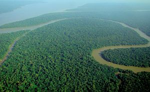
 Aerial view of the Amazon River | |
 Map of the Amazon basin | |
| 名前の由来 | Named after the Amazon Rainforest |
| 現地の呼称 | Amazonia |
| 所在 | |
| 国 | Brazil, Colombia, Peru, Ecuador |
| 州 |
Loreto (Peru); Amazonas (Columbia); North Region (Brazil) |
| 主な都市 |
Iquitos (Peru); Leticia (Colombia); Tabatinga (Brazil); Tefé (Brazil); Itacoatiara (Brazil); Parintins (Brazil); Óbidos (Brazil); Santarém (Brazil); Almeirim (Brazil); Macapá (Brazil) |
| 特性 | |
| 水源 | Nevado Mismi, Peru |
| • 所在地 | Arequipa Region |
| • 座標 | 南緯15度31分05秒 西経71度45分55秒 / 南緯15.51806度 西経71.76528度 |
| • 標高 | 5,170 m (16,960 ft) |
| 河口・合流先 | Atlantic Ocean |
• 所在地 | State of Amapá, State of Pará |
• 座標 | 南緯00度42分28秒 西経50度05分22秒 / 南緯0.70778度 西経50.08944度 |
• 標高 | 0 m (0 ft) |
| 延長 | 6,992 km (4,345 mi) |
| 流域面積 | 7,050,000 km2 (2,720,000 sq mi) |
| 川幅 | |
| • 最小 | 4 km (2.5 mi) |
| • 平均 | 6 km (3.7 mi) |
| • 最大 | 8 km (5.0 mi) |
| 水深 | |
| • 最小 | 3 m (9.8 ft) |
| • 平均 | 15 m (49 ft) |
| • 最大 | 30 m (98 ft) |
| 流量 | |
| • 観測地点 | Santarém, Pará |
| • 平均 | 209,000 m3/s (7,400,000 cu ft/s) |
| • 最少 | 109,000 m3/s (3,800,000 cu ft/s) |
| • 最大 | 309,000 m3/s (10,900,000 cu ft/s) |
| 流域 | |
| 流路 | Apurímac—Solimões—Marañón |
| 水系 | Amazon Basin |
| ランドマーク | Amazon Arena |
| 流域人口 | 1,234,567 |
| 主な支流 | |
| • 左岸 | |
| • 右岸 | |
| 主な湖 | Lake Lawriqucha |
| 主な滝 | Ahlfeld Waterfall |
| 主な橋 | Manaus–Iranduba Bridge |
| 河川港 | Port of Manaus |
| その他 | Custom data |
| (optional content at the bottom – centred) | |
このテンプレートは英語版の河川テンプレートを容易く移入できるようにするため、日本語版独自の改変を原則行いません。
使用方法は en:Template:Infobox river をご覧ください。
日本語化の細部の調整
編集所在地を示す項目を自由に設定できるようにデータ上に項目のラベルを持っているものがあります。これらを日本語に置き換えます。
- subdivision_type1 = 国<!--Countries-->
- subdivision_type2 = 州<!--States-->
- subdivision_type3 = 主な都市<!--Cities-->
- custom_label = '''''その他'''''<!--Custom label-->
関連項目
編集- Template:Infobox 河川 - 日本語版が使用する標準テンプレート
- プロジェクト:河川 - このテンプレートを管理するウィキプロジェクト
