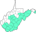
ファイル:Wvmapagain.png

このプレビューのサイズ: 774 × 599 ピクセル。 その他の解像度: 310 × 240 ピクセル | 620 × 480 ピクセル | 992 × 768 ピクセル | 1,280 × 991 ピクセル | 2,560 × 1,982 ピクセル | 6,587 × 5,100 ピクセル。
元のファイル (6,587 × 5,100 ピクセル、ファイルサイズ: 6.4メガバイト、MIME タイプ: image/png)
ファイルの履歴
過去の版のファイルを表示するには、その版の日時をクリックしてください。
| 日付と時刻 | サムネイル | 寸法 | 利用者 | コメント | |
|---|---|---|---|---|---|
| 現在の版 | 2016年11月30日 (水) 07:07 |  | 6,587 × 5,100 (6.4メガバイト) | Dubyavee | updated map with source and county names |
| 2008年5月31日 (土) 03:32 |  | 2,136 × 1,906 (342キロバイト) | Brianski | thumbnailable | |
| 2008年5月31日 (土) 03:28 |  | 4,270 × 3,810 (553キロバイト) | Brianski | {{Information |Description={{en|1=West Virginia Counties which ratified the Virginia ordinance of Secession on May 23, 1861.}} |Source=Data from Image:Wvmapagain.png by Dubyavee, with county shapes derived from [[:Image:Map_of_West_ |
ファイルの使用状況
以下のページがこのファイルを使用しています:
グローバルなファイル使用状況
以下に挙げる他のウィキがこの画像を使っています:
- en.wikipedia.org での使用状況
- ru.wikipedia.org での使用状況
