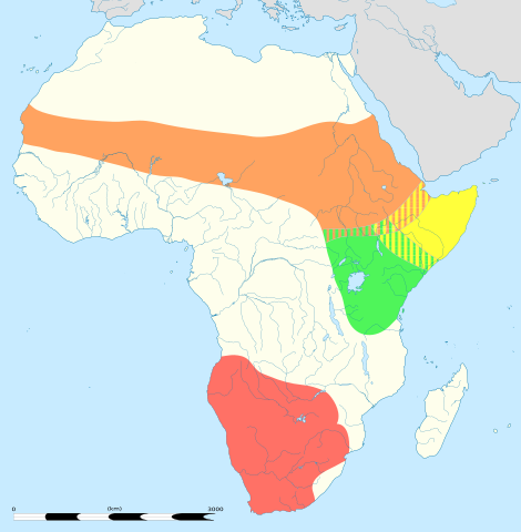
ファイル:Struthio camelus distribution.svg

この SVG ファイルのこの PNG プレビューのサイズ: 588 × 600 ピクセル. その他の解像度: 235 × 240 ピクセル | 470 × 480 ピクセル | 753 × 768 ピクセル | 1,004 × 1,024 ピクセル | 2,007 × 2,048 ピクセル | 687 × 701 ピクセル。
元のファイル (SVG ファイル、687 × 701 ピクセル、ファイルサイズ: 778キロバイト)
ウィキメディア・コモンズのファイルページにある説明を、以下に表示します。
|
概要
| 解説 |
English: An updated version to reflect the correct Southern African distribution as per Sasol Birds of Southern Africa (2011) |
| 日付 |
English: Blank administrative map of political Africa as in 2011-07, for geo-location purposes. On English Wikipedia, in "Template:Location_map_Africa" to set marker along curved latitude/longitude lines. Français : Carte administrative vierge de l'Afrique politique telle qu'en 07/2011, destinée à la géolocalisation. En Wikipédia Francais, a la Modèle:Géolocalisation/Afrique pour carte avec marqueur-image. A Lambert azimuthal equal-area projection, WGS84 datum *Standard meridian: 15°E *Standard parallel: 0° Scale: 1:23,420,000 (precision: 5,855 km) |
| 原典 |
このファイルの派生元: |
| 作者 |
|
| その他のバージョン | There is a version of this map with key and legends included in the graphic at File:Struthio camelus distribution with key.svg |

この画像には画像編集が施されています。原本に対して次のデジタル的な変更が行われました。
|
ライセンス
このファイルはクリエイティブ・コモンズ 表示-継承 3.0 非移植ライセンスのもとに利用を許諾されています。
- あなたは以下の条件に従う場合に限り、自由に
- 共有 – 本作品を複製、頒布、展示、実演できます。
- 再構成 – 二次的著作物を作成できます。
- あなたの従うべき条件は以下の通りです。
- 表示 – あなたは適切なクレジットを表示し、ライセンスへのリンクを提供し、変更があったらその旨を示さなければなりません。これらは合理的であればどのような方法で行っても構いませんが、許諾者があなたやあなたの利用行為を支持していると示唆するような方法は除きます。
- 継承 – もしあなたがこの作品をリミックスしたり、改変したり、加工した場合には、あなたはあなたの貢献部分を元の作品とこれと同一または互換性があるライセンスの下に頒布しなければなりません。
元のアップロードログ
This image is a derivative work of the following images:
- File:Struthio_camelus_Distribution_updated.png licensed with Cc-by-sa-3.0
- 2012-09-26T13:18:50Z Metatronx 1038x1270 (28425 Bytes) User created page with UploadWizard
- File:Africa_location_map.svg licensed with Cc-by-sa-3.0, GFDL
- 2012-10-02T12:40:15Z Palosirkka 1525x1440 (792744 Bytes) Reverted to version as of 19:13, 14 July 2011 Location maps must remain very accurate
- 2012-09-12T20:15:41Z Palosirkka 1525x1440 (537042 Bytes) Scrubbed with http://codedread.com/scour/
- 2011-07-14T19:13:55Z Sting 1525x1440 (792744 Bytes) Sudan/South Sudan 2011-07 border update
- 2010-07-02T20:12:15Z Sting 1525x1440 (586394 Bytes) == {{int:filedesc}} == {{Location|00|00|00|N|15|00|00|E|scale:30000000}} {{Information |Description={{en|Blank administrative map of political [[:en:Africa|Africa]], for geo-location purposes.}} {{fr|Carte administrative vier
Uploaded with derivativeFX
ファイルの履歴
過去の版のファイルを表示するには、その版の日時をクリックしてください。
| 日付と時刻 | サムネイル | 寸法 | 利用者 | コメント | |
|---|---|---|---|---|---|
| 現在の版 | 2013年8月22日 (木) 05:06 | | 687 × 701 (778キロバイト) | Begoon | position/keyline |
| 2013年8月21日 (水) 18:41 |  | 687 × 701 (902キロバイト) | Begoon | and re-crop | |
| 2013年8月21日 (水) 18:22 |  | 750 × 705 (901キロバイト) | Begoon | no legend | |
| 2013年8月21日 (水) 18:07 |  | 750 × 705 (932キロバイト) | Begoon | nah - better how it was | |
| 2013年8月21日 (水) 18:02 |  | 750 × 705 (932キロバイト) | Begoon | reduce legend size | |
| 2013年8月21日 (水) 16:06 |  | 750 × 705 (932キロバイト) | Begoon | tweak - square up legend key blocks after resize | |
| 2013年8月21日 (水) 15:41 |  | 750 × 705 (931キロバイト) | Begoon | shading | |
| 2013年8月21日 (水) 14:31 |  | 750 × 705 (914キロバイト) | Begoon | clearer colours for infobox | |
| 2013年8月21日 (水) 13:11 |  | 750 × 705 (919キロバイト) | Begoon | reduce yellow in land colour to increase yellow distrib area contrast | |
| 2013年8月21日 (水) 12:16 |  | 750 × 705 (919キロバイト) | Begoon | oops - fix crop properly |
ファイルの使用状況
以下のページがこのファイルを使用しています:
グローバルなファイル使用状況
以下に挙げる他のウィキがこの画像を使っています:
- af.wikipedia.org での使用状況
- am.wikipedia.org での使用状況
- ar.wikipedia.org での使用状況
- azb.wikipedia.org での使用状況
- ba.wikipedia.org での使用状況
- cs.wikipedia.org での使用状況
- de.wikipedia.org での使用状況
- en.wikipedia.org での使用状況
- es.wikipedia.org での使用状況
- gl.wikipedia.org での使用状況
- id.wikipedia.org での使用状況
- ilo.wikipedia.org での使用状況
- is.wikipedia.org での使用状況
- it.wikipedia.org での使用状況
- kn.wikipedia.org での使用状況
- kw.wikipedia.org での使用状況
- lt.wikipedia.org での使用状況
- mk.wikipedia.org での使用状況
- ms.wikipedia.org での使用状況
- my.wikipedia.org での使用状況
- pa.wikipedia.org での使用状況
- pl.wikipedia.org での使用状況
- pt.wikipedia.org での使用状況
- ru.wikipedia.org での使用状況
- sco.wikipedia.org での使用状況
- simple.wikipedia.org での使用状況
- sl.wikipedia.org での使用状況
- th.wikipedia.org での使用状況
- tr.wikipedia.org での使用状況
- vi.wikipedia.org での使用状況
- wa.wikipedia.org での使用状況