ファイル:South America southern tip pol.png

このプレビューのサイズ: 800 × 494 ピクセル。 その他の解像度: 320 × 198 ピクセル | 640 × 395 ピクセル | 1,024 × 632 ピクセル | 1,280 × 790 ピクセル | 2,560 × 1,581 ピクセル | 3,859 × 2,383 ピクセル。
元のファイル (3,859 × 2,383 ピクセル、ファイルサイズ: 596キロバイト、MIME タイプ: image/png)
ウィキメディア・コモンズのファイルページにある説明を、以下に表示します。
|
概要
| 解説 |
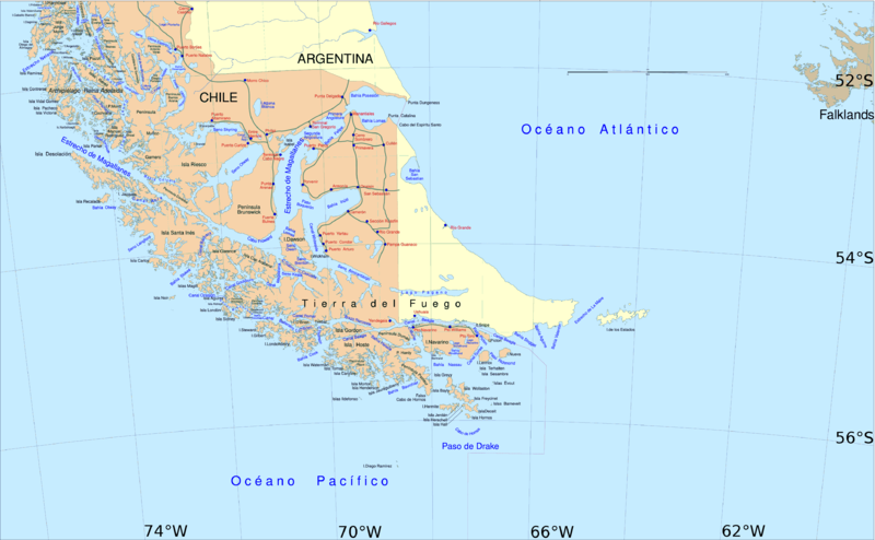
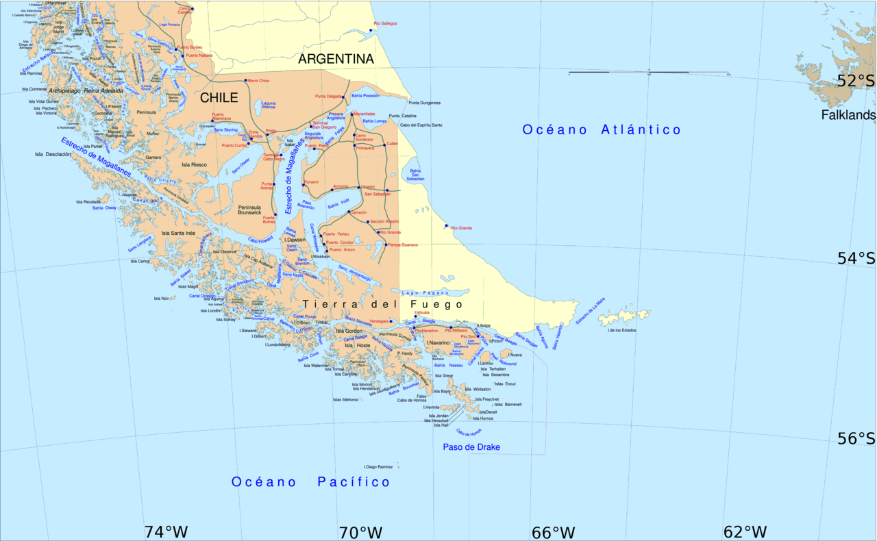
English: Political map of southern Chile and Argentina, from Straits of Magellan to Cape Horn.
Español: Mapa político del sur de Chile y la Argentina, entre el estrecho de Magallanes y el cabo de Hornos. |
||||
| 日付 | |||||
| 原典 | File:Sur2.gif | ||||
| 作者 | User:Createaccount | ||||
| 許可 (ファイルの再利用) |
|
||||
| その他のバージョン | このファイルの派生的著作物: Metula.svg |
ライセンス

|
この文書は、フリーソフトウェア財団発行のGNUフリー文書利用許諾書 (GNU Free Documentation License) 1.2またはそれ以降のバージョンの規約に基づき、複製や再配布、改変が許可されます。不可変更部分、表紙、背表紙はありません。このライセンスの複製は、GNUフリー文書利用許諾書という章に含まれています。 |
| このファイルはクリエイティブ・コモンズ 表示-継承 3.0 非移植ライセンスのもとに利用を許諾されています。 | ||
| ||
| このライセンスのテンプレートは、GFDLのライセンス・アップデートによりこのファイルに追加されたものです。 |
ファイルの履歴
過去の版のファイルを表示するには、その版の日時をクリックしてください。
| 日付と時刻 | サムネイル | 寸法 | 利用者 | コメント | |
|---|---|---|---|---|---|
| 現在の版 | 2016年4月30日 (土) 14:06 | | 3,859 × 2,383 (596キロバイト) | Hohum | Cartographic colours |
| 2013年4月3日 (水) 11:09 |  | 3,859 × 2,383 (597キロバイト) | Keysanger | Margin right and top cropped | |
| 2013年4月3日 (水) 10:47 |  | 3,859 × 2,383 (597キロバイト) | Keysanger | "Estrecho Nelson" added Bigger Latitude and Longitude within the image empty margin cropped | |
| 2009年5月3日 (日) 19:30 |  | 3,894 × 2,441 (639キロバイト) | Pitichinaccio | different colour | |
| 2009年5月3日 (日) 19:29 |  | 3,894 × 2,441 (639キロバイト) | Pitichinaccio | {{Information |Description={{en|1=political map of southern Chile/Argentina: From Straits of Magellan to Cape Horn}} |Source=File:Sur2.gif |Author=User:Createaccount |Date=2008 |Permission={{GFDL-GMT}}} |other_versions=File:Sur2.gif }} <!-- |
ファイルの使用状況
以下の 3 ページがこのファイルを使用しています:
グローバルなファイル使用状況
以下に挙げる他のウィキがこの画像を使っています:
- af.wikipedia.org での使用状況
- als.wikipedia.org での使用状況
- ar.wikipedia.org での使用状況
- ast.wikipedia.org での使用状況
- br.wikipedia.org での使用状況
- ca.wikipedia.org での使用状況
- de.wikipedia.org での使用状況
- de.wiktionary.org での使用状況
- el.wikipedia.org での使用状況
- en.wikipedia.org での使用状況
- Cape Froward
- Porvenir, Chile
- Santa Inés Island
- Puerto Toro
- False Cape Horn
- Puerto del Hambre
- Maritime history of California
- Brunswick Peninsula
- Almirantazgo Fjord
- Fjord of the Mountains
- Primera Angostura
- Aracena Island
- Punta Dúngeness
- Muñoz Gamero Peninsula
- Seno Otway
- Mitre Peninsula
- Marlborough (1876 ship)
このファイルのグローバル使用状況を表示する。