ファイル:Sierra Leone, administrative divisions - de - colored 2018.svg

元のファイル (SVG ファイル、1,606 × 1,606 ピクセル、ファイルサイズ: 220キロバイト)
ウィキメディア・コモンズのファイルページにある説明を、以下に表示します。
|
概要


.svg)


_(Paris_zoom).svg)
.svg)
,_administrative_divisions_-_de_-_colored_(multizoom).svg)
_-_colored.svg)
.svg)
,_administrative_divisions_-_Nmbrs_(multizoom).svg)
,_administrative_divisions_-_de_-_colored.svg)
_-_de_-_colored.svg)

.svg)

.svg)

|
この地図は、ドイツ語版の(地図研究室)で制作、もしくは改善されたものです。更なる改善の為、地図を提案することもできます。
|
ライセンス
Usage of this file with:

explanatory notes: Legally binding is only the full legalcode. For a free usage I recommend to respect the following licence conditions:
1. Provide my name as given above: NordNordWest,
2. a copy of, or the URI for, the applicable license: https://creativecommons.org/licenses/by-sa/3.0/de/legalcode,
3. the title of the work,
4. in the case of an adaptation, a credit identifying the use of the work in the adaptation.
This license and the rights granted hereunder will terminate automatically upon any breach by you of the terms of this license. Any of the above conditions can be waived if you get permission from the copyright holder. If you have questions or wish differing conditions, please contact me through nnwest or my discussion page ![]() t-online.de
t-online.de
- あなたは以下の条件に従う場合に限り、自由に
- 共有 – 本作品を複製、頒布、展示、実演できます。
- 再構成 – 二次的著作物を作成できます。
- あなたの従うべき条件は以下の通りです。
- 表示 – あなたは適切なクレジットを表示し、ライセンスへのリンクを提供し、変更があったらその旨を示さなければなりません。これらは合理的であればどのような方法で行っても構いませんが、許諾者があなたやあなたの利用行為を支持していると示唆するような方法は除きます。
- 継承 – もしあなたがこの作品をリミックスしたり、改変したり、加工した場合には、あなたはあなたの貢献部分を元の作品とこれと同一または互換性があるライセンスの下に頒布しなければなりません。

ファイルの履歴
過去の版のファイルを表示するには、その版の日時をクリックしてください。
| 日付と時刻 | サムネイル | 寸法 | 利用者 | コメント | |
|---|---|---|---|---|---|
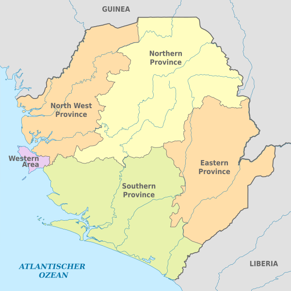
| 現在の版 | 2018年1月19日 (金) 15:40 | | 1,606 × 1,606 (220キロバイト) | NordNordWest | == {{int:filedesc}} == {{Information |description= {{de|Karte der politischen Gliederung von Sierra Leone, 2018}} {{en|Map of administrative divisions of Sierra Leone, 2018}} |source={{Own using}} {{f|Saarland location map.svg}} by {{U|Lantus}} |date={... |
ファイルの使用状況
以下の 2 ページがこのファイルを使用しています:
グローバルなファイル使用状況
以下に挙げる他のウィキがこの画像を使っています:
- ab.wikipedia.org での使用状況
- ar.wikipedia.org での使用状況
- ca.wikipedia.org での使用状況
- de.wikipedia.org での使用状況
- en.wikipedia.org での使用状況
- es.wikipedia.org での使用状況
- frr.wikipedia.org での使用状況
- he.wikipedia.org での使用状況
- hr.wikipedia.org での使用状況
- hu.wiktionary.org での使用状況
- id.wikipedia.org での使用状況
- it.wikipedia.org での使用状況
- lt.wikipedia.org での使用状況
- mdf.wikipedia.org での使用状況
- nl.wikipedia.org での使用状況
- no.wikipedia.org での使用状況
- pt.wikipedia.org での使用状況
- ro.wikipedia.org での使用状況
- sv.wikipedia.org での使用状況
- tr.wikipedia.org での使用状況
- zh.wikipedia.org での使用状況