ファイル:Pennsylvania Railroad system map (1918).svg

この SVG ファイルのこの PNG プレビューのサイズ: 800 × 457 ピクセル. その他の解像度: 320 × 183 ピクセル | 640 × 366 ピクセル | 1,024 × 585 ピクセル | 1,280 × 731 ピクセル | 2,560 × 1,463 ピクセル | 1,400 × 800 ピクセル。
元のファイル (SVG ファイル、1,400 × 800 ピクセル、ファイルサイズ: 6.55メガバイト)
ウィキメディア・コモンズのファイルページにある説明を、以下に表示します。
|
.svg?uselang=ja)
.svg?uselang=ja)
.svg?uselang=ja&action=history)
.svg)
概要
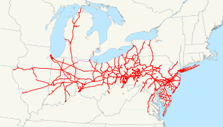
| 解説 | This is a map of the Pennsylvania Railroad system as of 1918, with trackage rights in purple and future lines dotted. The two disconnected pieces in West Virginia are not an error; they are remaining portions of the Little Kanawha Syndicate properties that were partially controlled by the PRR-owned Pennsylvania Company. Email me if you would like a copy of the GIS data I created (modified from Bureau of Transportation Statistics North American Transportation Atlas Data) or if you see any errors. |
| 日付 | 2009年3月18日 (当初のアップロード日) |
| 原典 | コンピュータが読み取れる情報は提供されていませんが、投稿者自身による著作物だと推定されます(著作権の主張に基づく) |
| 作者 | コンピュータが読み取れる情報は提供されていませんが、NE2だと推定されます(著作権の主張に基づく) |
ライセンス
| この著作物の著作権者である私は、この著作物における権利を放棄しパブリックドメインとします。これは全世界で適用されます。 一部の国では、これが法的に可能ではない場合があります。その場合は、次のように宣言します。 私は、あらゆる人に対して、法により必要とされている条件を除き、如何なる条件も課すことなく、あらゆる目的のためにこの著作物を使用する権利を与えます。 |
ファイルの履歴
過去の版のファイルを表示するには、その版の日時をクリックしてください。
| 日付と時刻 | サムネイル | 寸法 | 利用者 | コメント | |
|---|---|---|---|---|---|
| 現在の版 | 2009年3月19日 (木) 03:23 | | 1,400 × 800 (6.55メガバイト) | NE2 | Fixed just a bit. |
| 2009年3月18日 (水) 05:13 |  | 1,400 × 800 (6.53メガバイト) | NE2 | Changed the zoom slightly. | |
| 2009年3月18日 (水) 04:49 |  | 1,400 × 800 (6.6メガバイト) | NE2 | == Summary == This is a map of the Pennsylvania Railroad system as of 1918, with trackage rights in purple and future lines dotted. The two disconnected pieces in West Virginia are not an error; they are remaining portions of the Li |
ファイルの使用状況
以下のページがこのファイルを使用しています:
グローバルなファイル使用状況
以下に挙げる他のウィキがこの画像を使っています:
- de.wikipedia.org での使用状況
- et.wikipedia.org での使用状況
- fr.wikipedia.org での使用状況
- hu.wikipedia.org での使用状況
- it.wikipedia.org での使用状況
- ko.wikipedia.org での使用状況
- nl.wikipedia.org での使用状況
- pt.wikipedia.org での使用状況
- ru.wikipedia.org での使用状況
- www.wikidata.org での使用状況
.svg)