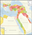
ファイル:Ottoman Empire Administrative Divisions.png

このプレビューのサイズ: 552 × 600 ピクセル。 その他の解像度: 221 × 240 ピクセル | 442 × 480 ピクセル | 707 × 768 ピクセル | 943 × 1,024 ピクセル | 1,885 × 2,048 ピクセル | 4,455 × 4,840 ピクセル。
元のファイル (4,455 × 4,840 ピクセル、ファイルサイズ: 2.1メガバイト、MIME タイプ: image/png)
ファイルの履歴
過去の版のファイルを表示するには、その版の日時をクリックしてください。
| 日付と時刻 | サムネイル | 寸法 | 利用者 | コメント | |
|---|---|---|---|---|---|
| 現在の版 | 2021年11月16日 (火) 07:16 |  | 4,455 × 4,840 (2.1メガバイト) | BasilLeaf | updates |
| 2021年5月5日 (水) 19:22 |  | 4,455 × 4,840 (2.11メガバイト) | Super Dromaeosaurus | Romanian Black Sea Snake Island, Romanian-Russian border at Dobruja-Bessarabia, removed lands in Banat that didn't belong to Romania then | |
| 2021年4月14日 (水) 18:17 |  | 4,455 × 4,840 (2.03メガバイト) | محمد٢ | Reverted to version as of 18:40, 19 January 2021 (UTC) | |
| 2021年2月8日 (月) 02:05 |  | 4,455 × 4,840 (2.1メガバイト) | BasilLeaf | Minor name fixes. Iran's official English name was "Sublime State of Persia". "Arab Gulf" Doesn't exist. There's "Arabian Gulf", a name that only came to decently widespread usage from 1960s. Contemporary internationally accepted term is "Persian Gulf". | |
| 2021年1月19日 (火) 18:40 |  | 4,455 × 4,840 (2.03メガバイト) | Userd898 | minor edit regarding the recoloring of a wrongly colored spot in haasa | |
| 2021年1月19日 (火) 18:05 |  | 4,455 × 4,840 (2.03メガバイト) | Userd898 | fixed some mistakes in yemen and labeled qatar as occupied source: https://www.euratlas.net/history/hisatlas/arabia/1904__AR.html | |
| 2021年1月14日 (木) 18:48 |  | 4,455 × 4,840 (2.1メガバイト) | BasilLeaf | Minor name fixes. Iran's official English name was "Sublime State of Persia". "Arab Gulf" Doesn't exist. There's "Arabian Gulf", a name that only came to decently widespread usage in 1960s. | |
| 2020年12月27日 (日) 19:15 |  | 4,455 × 4,840 (2.03メガバイト) | Userd898 | Uploaded own work with UploadWizard |
ファイルの使用状況
以下のページがこのファイルを使用しています:
グローバルなファイル使用状況
以下に挙げる他のウィキがこの画像を使っています:
- bg.wikipedia.org での使用状況
- bn.wikipedia.org での使用状況
- ca.wikipedia.org での使用状況
- ckb.wikipedia.org での使用状況
- de.wikipedia.org での使用状況
- el.wikipedia.org での使用状況
- en.wikipedia.org での使用状況
- Ottoman Empire
- Sanjak
- Administrative divisions of the Ottoman Empire
- Kosovo vilayet
- Baghdad vilayet
- Mosul vilayet
- Scutari vilayet
- Basra vilayet
- Ottoman Tripolitania
- Ottoman Syria
- Abdul Hamid II
- Ottoman Iraq
- Mount Lebanon Mutasarrifate
- Janina vilayet
- Beirut vilayet
- Syria vilayet
- Hejaz vilayet
- Talk:Greater Palestine
- User:Falcaorib/Contemporary Empires (1800-2024 AD)
- User:Falcaorib/Turkey and Ottoman Empire
- es.wikipedia.org での使用状況
- fa.wikipedia.org での使用状況
- fi.wikipedia.org での使用状況
- fr.wikipedia.org での使用状況
- gl.wikipedia.org での使用状況
- he.wikipedia.org での使用状況
- it.wikipedia.org での使用状況
このファイルのグローバル使用状況を表示する。

