ファイル:Japanese Empire - 1942.svg

この SVG ファイルのこの PNG プレビューのサイズ: 788 × 600 ピクセル. その他の解像度: 316 × 240 ピクセル | 631 × 480 ピクセル | 1,009 × 768 ピクセル | 1,280 × 974 ピクセル | 2,560 × 1,948 ピクセル | 1,100 × 837 ピクセル。
元のファイル (SVG ファイル、1,100 × 837 ピクセル、ファイルサイズ: 875キロバイト)
ウィキメディア・コモンズのファイルページにある説明を、以下に表示します。
|
概要
| 解説 |
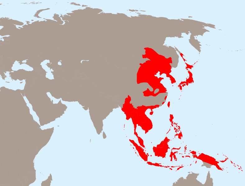
English: The Empire of Japan at its height in 1942.
Français : Japon 1942
Deutsch: Japanisches Reich 1942 |
| 日付 | |
| 原典 | 次の画像を基にした投稿者自身による著作物: Empire of Japan (1868-1945).png 次のものによる: Mackay 86、Asie.svg 次のものによる: historicairおよび;Japanese Empire2.png 次のものによる: Mackay 86 |
| 作者 |
ベクタ: |
| SVG 開発 |
.png)
ライセンス
このファイルはクリエイティブ・コモンズ 表示-継承 3.0 非移植ライセンスのもとに利用を許諾されています。
- あなたは以下の条件に従う場合に限り、自由に
- 共有 – 本作品を複製、頒布、展示、実演できます。
- 再構成 – 二次的著作物を作成できます。
- あなたの従うべき条件は以下の通りです。
- 表示 – あなたは適切なクレジットを表示し、ライセンスへのリンクを提供し、変更があったらその旨を示さなければなりません。これらは合理的であればどのような方法で行っても構いませんが、許諾者があなたやあなたの利用行為を支持していると示唆するような方法は除きます。
- 継承 – もしあなたがこの作品をリミックスしたり、改変したり、加工した場合には、あなたはあなたの貢献部分を元の作品とこれと同一または互換性があるライセンスの下に頒布しなければなりません。
元のアップロードログ
This image is a derivative work of the following images:
- Empire of Japan (1868-1945).png licensed with PD-user-w
- 2010-04-13T05:49:21Z File Upload Bot (Magnus Manske) 1000x600 (183888 Bytes) {{BotMoveToCommons|en.wikipedia|year={{subst:CURRENTYEAR}}|month={{subst:CURRENTMONTHNAME}}|day={{subst:CURRENTDAY}}}} {{Information |Description={{en|The Empire of Japan at its height in 1942.}} |Source=Transferred from [ht
- Asie.svg licensed with PD-self
- 2006-11-23T21:09:53Z Historicair 1100x837 (902355 Bytes)
- 2006-11-23T20:25:19Z Historicair 1100x837 (902408 Bytes)
- 2006-11-22T22:59:34Z Historicair 1100x837 (898316 Bytes)
- 2006-11-21T18:36:45Z Historicair 1100x837 (897827 Bytes)
- 2006-11-20T20:31:48Z Historicair 1100x837 (816138 Bytes) {{Information |Description={{fr|1=Carte vierge de l'Asie }}{{en|1=Asia Blank map}} |Source=http://en.wikipedia.org/wiki/Image:BlankMap-World5.svg |Date=20/11/2006 |Author=~~~~ |Permission={{PD-self}} |other_versions= }} {{Atelier g
- Japanese Empire2.png licensed with Cc-by-sa-3.0-migrated, GFDL
- 2007-07-05T11:47:48Z Mahahahaneapneap 707x591 (32385 Bytes) pngcrushed
- 2007-05-27T01:31:13Z Gryffindor 707x591 (49084 Bytes) {{svg}} {{GFDL}} Modified version of [[:Image:Japanese_Empire.png]]. Fixed Ryukyu Islands, Sichuan, grammar in table. [[Category:Maps of the history of Japan]] [[Category:Maps of the history of Korea]] [[Category:Maps of th
- 2007-02-27T15:13:21Z Cristan 508x591 (37210 Bytes) Optimized using PNGOUT
- 2005-12-22T11:24:51Z Markalexander100 508x591 (47890 Bytes) {{GFDL}} Modified version of [[:Image:Japanese_Empire.png]]. Fixed Ryukyu Islands, Sichuan, grammar in table.
Uploaded with derivativeFX
ファイルの履歴
過去の版のファイルを表示するには、その版の日時をクリックしてください。
| 日付と時刻 | サムネイル | 寸法 | 利用者 | コメント | |
|---|---|---|---|---|---|
| 現在の版 | 2020年3月31日 (火) 20:13 | | 1,100 × 837(875キロバイト) | Esmu Igors | Northern part of the Sakhalin island was transferred from Japan to Soviet Russia in 1925, and the borders remained untouched until the end of WWII. Hence this territory should be omitted from the map. |
| 2020年3月31日 (火) 20:13 |  | 1,100 × 837(904キロバイト) | Esmu Igors | Reverted to version as of 01:24, 25 April 2010 (UTC) (unsuccessful edit in the Inkscape) | |
| 2020年3月31日 (火) 20:11 |  | 1,100 × 837(882キロバイト) | Esmu Igors | Northern part of the Sakhalin island was transferred from Japan to Soviet Russia in 1925, and the borders remained untouched until the end of WWII. Hence this territory should be omitted from the map. | |
| 2010年4月25日 (日) 01:24 |  | 1,100 × 837(904キロバイト) | Ras67 | borders removed | |
| 2010年4月23日 (金) 21:44 |  | 1,100 × 837(911キロバイト) | TastyCakes | Tweaked some borders and coloured some islands that I missed | |
| 2010年4月23日 (金) 21:29 |  | 1,100 × 837(911キロバイト) | TastyCakes | {{Information |Description={{en|The Empire of Japan at its height in 1942.}} {{fr}}Carte vierge de l'Asie {{en}}Asia Blank map |Source=*File:Empire_of_Japan_(1868-1945).png *File:Asie.svg *File:Japanese_Empire2.png |Date=2010-04-23 21:26 |
.png)
ファイルの使用状況
以下のページがこのファイルを使用しています:
グローバルなファイル使用状況
以下に挙げる他のウィキがこの画像を使っています:
- ar.wikipedia.org での使用状況
- bcl.wikipedia.org での使用状況
- be.wikipedia.org での使用状況
- cs.wikipedia.org での使用状況
- de.wikipedia.org での使用状況
- en.wikipedia.org での使用状況
- fo.wikipedia.org での使用状況
- fr.wikipedia.org での使用状況
- id.wikipedia.org での使用状況
- it.wikipedia.org での使用状況
- km.wikipedia.org での使用状況
- ms.wikipedia.org での使用状況
- no.wikipedia.org での使用状況
- ru.wikipedia.org での使用状況
- simple.wikipedia.org での使用状況
- sv.wikipedia.org での使用状況
- th.wikipedia.org での使用状況
- tl.wikipedia.org での使用状況
- uk.wikipedia.org での使用状況
- zh-min-nan.wikipedia.org での使用状況
- zh-yue.wikipedia.org での使用状況
- zh.wikipedia.org での使用状況
このファイルのグローバル使用状況を表示する。