ファイル:Apsley house on an 1869 Ordnance Survey Map.JPG
高解像度版はありません。
Apsley_house_on_an_1869_Ordnance_Survey_Map.JPG (500 × 492 ピクセル、ファイルサイズ: 79キロバイト、MIME タイプ: image/jpeg)
ウィキメディア・コモンズのファイルページにある説明を、以下に表示します。
|

|
このファイルは、en.wikipediaからボットスクリプトを使用してウィキメディア・コモンズへ移されました。すべての情報源が存在しますが、これらはチェックが必要です。情報のいずれか、または全部がエラーであるかもしれず、それらに信頼性が確認できないかもしれません。チェックがなされるまで、このファイルは利用すべきではありません。必要な訂正を行ってレビューが完了した場合は、このテンプレートを除去できます。詳細は、下記をご覧ください。 編集する。 |
| 解説 |
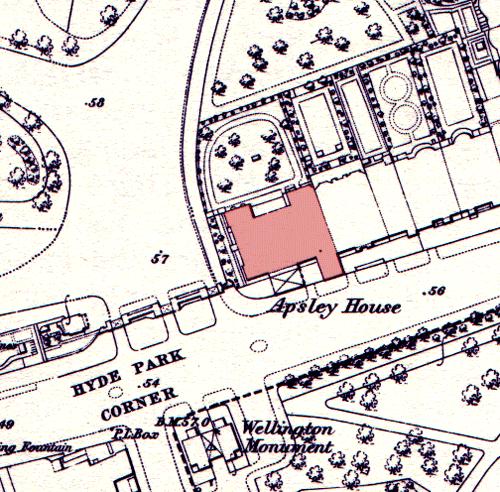
English: Apsley House on an 1869 Ordnance Survey map, showing its position at the end of a terrace. The neighbouring houses were demolished in the post World War II period to allow Park Lane to be straightened and widened. The Wellington Monument has been moved since this time. |
| 日付 | 2005年5月15日 (当初のアップロード日) |
| 原典 | en.wikipedia からコモンズに Oxyman によって CommonsHelper を用いて移動されました。 |
| 作者 | オリジナルのアップロード者は英語版ウィキペディアのOliver Chettleさん |
ライセンス
This work is an Ordnance Survey map over 50 years old, which is covered by Crown Copyright which in this case expires 50 years after publication. Ordnance Survey does however ask that they be credited and that the date of publication be given.
Any ancillary rights gained through the creation of the electronic version are granted as freely usable under any circumstances.
|
この作品は、イギリス政府の管轄内で作られ、パブリックドメインで提供されています。
以下の1つに当てはまります。
HMSOは、クラウン・コピーライトの保護期間満了が全世界で適用されることを宣言しました。この点は、寄せられたHMSOのメーリングリストで確認できます。 以上の著作権状態に関する文章は、参考訳です。
クラウン・コピーライトの詳細は、OPSI、クラウン・コピーライトの期間で確認する必要があります。また、著作権も参考にします。
|
 |
元のアップロードログ
元のファイルページはこちら。以下の利用者は全てen.wikipediaに属します。
- 2005-05-15 08:53 Oliver Chettle 500×492× (80749 bytes) Apsley House on an 1869 [[Ordnance Survey]] map, showing its position at the end of a terrace. The neighbouring houses were demolished in the post [[World War II]] period to allow [[Park Lane]] to be widened. The [[Wellington Monument]] has been moved sin
ファイルの履歴
過去の版のファイルを表示するには、その版の日時をクリックしてください。
| 日付と時刻 | サムネイル | 寸法 | 利用者 | コメント | |
|---|---|---|---|---|---|
| 現在の版 | 2009年10月5日 (月) 23:23 | | 500 × 492 (79キロバイト) | File Upload Bot (Magnus Manske) | {{BotMoveToCommons|en.wikipedia|year={{subst:CURRENTYEAR}}|month={{subst:CURRENTMONTHNAME}}|day={{subst:CURRENTDAY}}}} {{Information |Description={{en|Apsley House on an 1869 en:Ordnance Survey map, showing its position at the end of a terrace. The |
ファイルの使用状況
以下の 3 ページがこのファイルを使用しています:
グローバルなファイル使用状況
以下に挙げる他のウィキがこの画像を使っています:
- ar.wikipedia.org での使用状況
- en.wikipedia.org での使用状況
- es.wikipedia.org での使用状況
- fr.wikipedia.org での使用状況
- zh.wikipedia.org での使用状況