ファイル:Americas independence map.PNG

このプレビューのサイズ: 407 × 600 ピクセル。 その他の解像度: 163 × 240 ピクセル | 326 × 480 ピクセル | 862 × 1,270 ピクセル。
元のファイル (862 × 1,270 ピクセル、ファイルサイズ: 74キロバイト、MIME タイプ: image/png)
ウィキメディア・コモンズのファイルページにある説明を、以下に表示します。
|

|
このhistorical map画像は、ベクターイメージである SVG ファイルとして再作成されるべきです。これにはいくつかの利点があります。詳しくはCommons:Media for cleanupを参照してください。この画像の SVG 形式がすでに利用可能である場合は、アップロードしてください。アップロード後、この画像にあるこのテンプレートを{{Vector version available|新しい画像ファイル名.svg}}テンプレートで置き換えてください。
|
概要
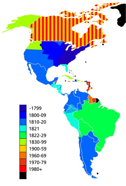
Map showing date of independence of country in the Americas. Black shows areas not yet independent.
Uses current boundaries, which may not correspond with the historical boundary of the country when it became independent. For example the United States was composed of 13 states on the East Coast when it became independent and did not reach its full continental extant until 1867 with the .
ライセンス

|
この文書は、フリーソフトウェア財団発行のGNUフリー文書利用許諾書 (GNU Free Documentation License) 1.2またはそれ以降のバージョンの規約に基づき、複製や再配布、改変が許可されます。不可変更部分、表紙、背表紙はありません。このライセンスの複製は、GNUフリー文書利用許諾書という章に含まれています。 |
| このファイルはクリエイティブ・コモンズ 表示-継承 3.0 非移植ライセンスのもとに利用を許諾されています。 | ||
| ||
| このライセンスのテンプレートは、GFDLのライセンス・アップデートによりこのファイルに追加されたものです。 |
ファイルの履歴
過去の版のファイルを表示するには、その版の日時をクリックしてください。
| 日付と時刻 | サムネイル | 寸法 | 利用者 | コメント | |
|---|---|---|---|---|---|
| 現在の版 | 2019年5月11日 (土) 14:23 | | 862 × 1,270 (74キロバイト) | Foghe | Removed Labrador border; only current international borders. |
| 2019年4月25日 (木) 03:32 |  | 862 × 1,270 (44キロバイト) | Marcomogollon | I add disputed territory between Colombia, Ecuador and Peru | |
| 2011年10月3日 (月) 23:11 |  | 862 × 1,270 (68キロバイト) | Lemonade100 | Added some current dependent territories and re-coded Canada - gained sovereignty in 1939 and full independence in 1982. | |
| 2010年11月9日 (火) 18:35 |  | 862 × 1,270 (38キロバイト) | Minnecologies | Fixed error in northern Canada | |
| 2010年11月9日 (火) 17:25 |  | 862 × 1,270 (38キロバイト) | Minnecologies | *Filled in Pacific Northwest *Added Saint Pierre and Miquelon *Updated the boundaries of Gran Colombia, Bolivia, and Peru *Changed color scheme to straight ROYGBIV | |
| 2007年8月20日 (月) 06:32 |  | 862 × 1,270 (61キロバイト) | AlexCovarrubias | Mexico independence year is 1810 | |
| 2006年12月7日 (木) 00:48 |  | 862 × 1,270 (49キロバイト) | Roke~commonswiki | include colonies | |
| 2006年3月22日 (水) 12:48 |  | 862 × 1,270 (63キロバイト) | Roke~commonswiki | Map showing date of independence of country in the Americas Category: America |
ファイルの使用状況
以下のページがこのファイルを使用しています:
グローバルなファイル使用状況
以下に挙げる他のウィキがこの画像を使っています:
- ar.wikipedia.org での使用状況
- bg.wikipedia.org での使用状況
- cs.wikipedia.org での使用状況
- de.wikipedia.org での使用状況
- en.wikipedia.org での使用状況
- es.wikipedia.org での使用状況
- fa.wikipedia.org での使用状況
- fi.wikipedia.org での使用状況
- fr.wikipedia.org での使用状況
- fy.wikipedia.org での使用状況
- gl.wikipedia.org での使用状況
- kn.wikipedia.org での使用状況
- ms.wikipedia.org での使用状況
- nds-nl.wikipedia.org での使用状況
- nl.wikipedia.org での使用状況
- pt.wikipedia.org での使用状況
- sd.wikinews.org での使用状況
- uk.wikipedia.org での使用状況
- www.wikidata.org での使用状況
- wo.wikipedia.org での使用状況
- zh.wikipedia.org での使用状況