ファイル:1847 Levasseur Map of Sarthe, France - Geographicus - Sarthe-levasseur-1847.jpg
このプレビューのサイズ: 800 × 561 ピクセル。 その他の解像度: 320 × 224 ピクセル | 640 × 449 ピクセル | 1,024 × 718 ピクセル | 1,280 × 898 ピクセル | 2,560 × 1,796 ピクセル | 5,177 × 3,631 ピクセル。
元のファイル (5,177 × 3,631 ピクセル、ファイルサイズ: 4.68メガバイト、MIME タイプ: image/jpeg)
ウィキメディア・コモンズのファイルページにある説明を、以下に表示します。
|
| Dept. De La Sarthe. | ||||||||||||||||||||||||||||||||||||
|---|---|---|---|---|---|---|---|---|---|---|---|---|---|---|---|---|---|---|---|---|---|---|---|---|---|---|---|---|---|---|---|---|---|---|---|---|
| 作者 |
|
|||||||||||||||||||||||||||||||||||
| タイトル |
Dept. De La Sarthe. |
|||||||||||||||||||||||||||||||||||
| 解説 |
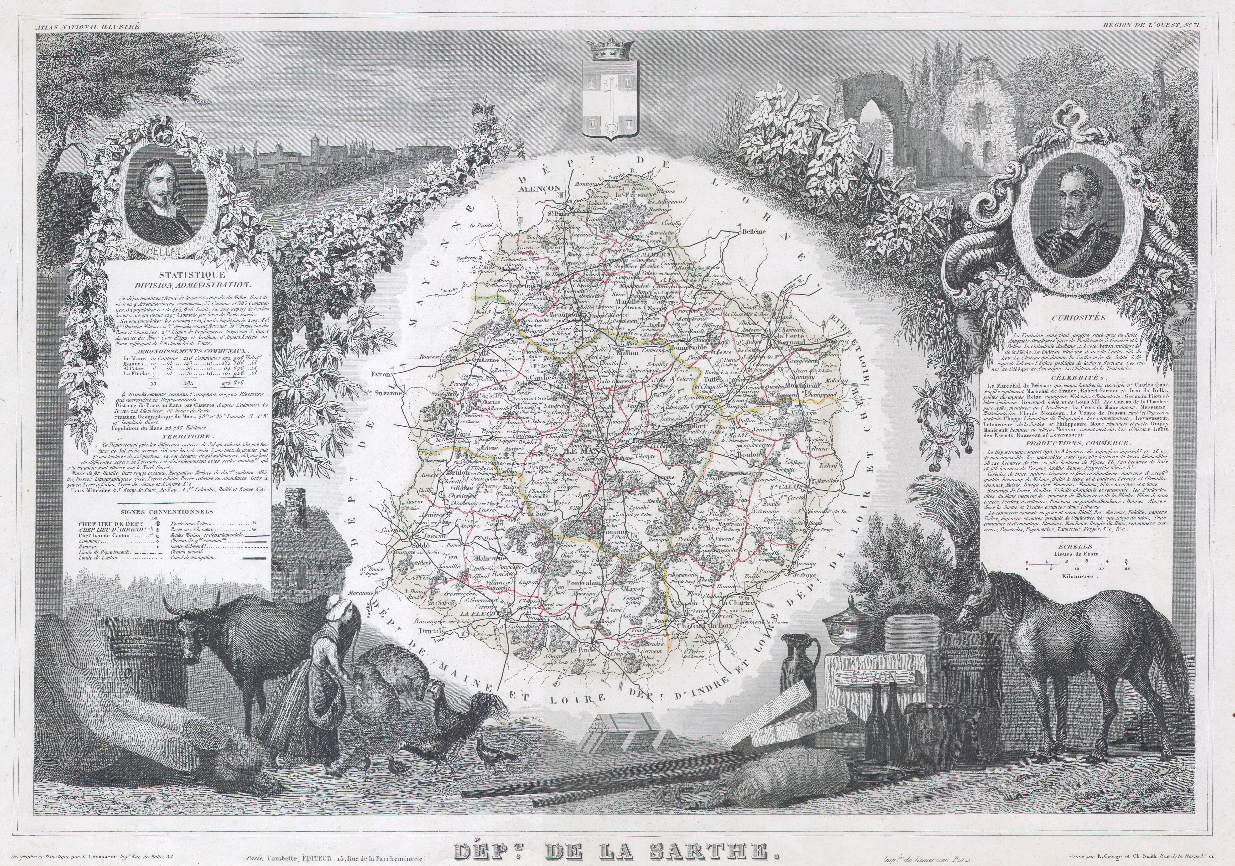
English: This is a fascinating 1847 map of the French department of Sarthe, surrounding the city of Le Mans. Sarthe is a Loire valley wine growing region that specializes in the lesser known French varietals of Jasnieres and Coteaux du Loir. It is also one of the primary areas where the oak barrels for many European wines are produced. The whole is surrounded by elaborate decorative engravings designed to illustrate both the natural beauty and trade richness of the land. There is a short textual history of the regions depicted on both the left and right sides of the map. |
|||||||||||||||||||||||||||||||||||
| 日付 | 1847年 | |||||||||||||||||||||||||||||||||||
| 寸法 | 高さ: 12 in (30.4 cm);幅: 17 in (43.1 cm) | |||||||||||||||||||||||||||||||||||
| 台帳番号 |
Geographicus link: Sarthe-levasseur-1847 |
|||||||||||||||||||||||||||||||||||
| 情報源/撮影者 |
|
|||||||||||||||||||||||||||||||||||
| 許可 (ファイルの再利用) |
|
|||||||||||||||||||||||||||||||||||
| その他のバージョン |
|
|||||||||||||||||||||||||||||||||||

ファイルの履歴
過去の版のファイルを表示するには、その版の日時をクリックしてください。
| 日付と時刻 | サムネイル | 寸法 | 利用者 | コメント | |
|---|---|---|---|---|---|
| 現在の版 | 2011年3月16日 (水) 08:51 | | 5,177 × 3,631 (4.68メガバイト) | BotMultichill | {{subst:User:Multichill/Geographicus |link=http://www.geographicus.com/P/AntiqueMap/Sarthe-levasseur-1847 |product_name=1847 Levasseur Map of Sarthe, France |map_title=Dept. De La Sarthe. |description=This is a fascinating 1847 map of the French departm |
ファイルの使用状況
以下のページがこのファイルを使用しています:
グローバルなファイル使用状況
以下に挙げる他のウィキがこの画像を使っています:
- fr.wikipedia.org での使用状況